Nebraska commercial property due diligence has one localized issue found almost nowhere else in the US: Natural Resources Districts (NRDs). Nebraska's 23 NRDs regulate groundwater use within their boundaries and can impose pumping restrictions, moratoriums, or control areas on commercial properties that rely on groundwater in over-appropriated aquifer basins - including parts of the Platte River Basin and other regulated areas.
Nebraska's Documentary Stamp Tax (NE Rev. Stat. §76-901): $2.25 per $1,000 of consideration at the state level; counties may levy an additional $0.75 per $1,000 for a combined rate of up to $3.00 per $1,000 (0.30%); typically paid by the grantor. Most Nebraska commercial closings use warranty deeds, with the deed of trust as the standard commercial security instrument.
Nebraska's commercial real estate market centers on Omaha (Douglas and Sarpy counties) and Lincoln (Lancaster County). Omaha's commercial history includes significant meat-packing, railroad, and industrial legacy that created brownfield corridors along the Missouri River and rail lines; the Nebraska Department of Environment and Energy (NDEE) oversees contaminated site cleanup through its Voluntary Cleanup Program (VCP).
Nebraska water law is unique nationally because it combines the prior appropriation doctrine for surface water with a correlative rights system for groundwater, and then overlays both with the 2004 Integrated Management Act (IMA) linking surface and groundwater management in over-appropriated basins. For any commercial property relying on groundwater, NRD status and groundwater allocation must be confirmed before closing.
Set up a due diligence data room before advisors engage. Load ALTA title, NRD groundwater records, NDEE contamination records, USDA conservation easement records, FEMA flood data, and lease files before diligence opens.
Where Nebraska property deals go wrong
Not every check carries the same weight. The table below sorts risks by deal impact - dealbreakers first, then what moves the price, then basic hygiene - so your Nebraska attorney and environmental consultant know what to clear first.
| Area | Documents to pull | NE red flag | Matters most for | Tier | |
|---|---|---|---|---|---|
| Title - register of deeds | Title - register of deeds | ALTA owner's title commitment, county register of deeds records, ALTA/NSPS survey, UCC fixture filing search at NE Secretary of State | Nebraska property records are at each county's register of deeds office; Nebraska commercial transactions typically use warranty deeds; deeds of trust are the standard security instrument for commercial lending; check for any agricultural easements, drainage district easements, or USDA conservation program easements (CRP, CREP, WRP) running with the land - these restrict commercial or development use and are not always visible in a standard title search | All buyers | Dealbreaker |
| NRD groundwater and IMA controls | NRD groundwater and IMA controls | Local NRD records for the applicable district, NRD groundwater control area maps, NE DNR integrated management plan for the relevant basin, existing water well permits from NE DNR | Nebraska's 23 Natural Resources Districts regulate groundwater use locally; NRDs can declare groundwater control areas, impose moratoriums on new wells, restrict pumping volumes, and require offsets for new groundwater use; the 2004 Integrated Management Act (IMA) links surface water and groundwater management in basins declared over-appropriated; the Platte River Basin (including Central Platte NRD, Twin Platte NRD, Lower Platte North NRD, Lower Platte South NRD, Upper Big Blue NRD) has active integrated management plans; commercial properties in these basins that depend on groundwater need to confirm whether their water use is permitted and whether NRD restrictions will affect operations | All groundwater-dependent NE commercial; agricultural and industrial | Dealbreaker |
| USDA conservation easements | USDA conservation easements | USDA FSA CRP contract records (county FSA office), USDA NRCS RCPP and CREP records, Wetland Reserve Easement (WRE) records at county level | Nebraska has a very high proportion of farmland enrolled in USDA conservation programs including the Conservation Reserve Program (CRP), Wetland Reserve Easements (WRE/WRP), and Conservation Reserve Enhancement Program (CREP); CRP contracts run for 10-15 years and prohibit most non-agricultural use of enrolled land; WRE easements are often permanent and run with the land; commercial developers targeting former agricultural parcels in Nebraska must check USDA FSA records at the county office before any commercial use assumption | Rural and peri-urban Nebraska commercial; agricultural conversion | Dealbreaker |
| Environmental - NDEE VCP and Omaha industrial | Environmental - NDEE VCP and Omaha industrial | Phase I ESA (ASTM E1527-21), NDEE contaminated sites database, NDEE UST database, EPA Superfund NPL, RCRA database | NDEE operates a Voluntary Cleanup Program (VCP) for brownfield buyers; a Certificate of Completion provides regulatory closure; Omaha has significant industrial legacy contamination from meat-packing plants, railroad yards (Union Pacific), and chemical manufacturing along the Missouri River; the South Omaha industrial corridor has documented soil and groundwater contamination; search NDEE contaminated sites database before bidding on any Omaha industrial-legacy commercial | Omaha industrial-legacy commercial, South Omaha corridor | Dealbreaker |
| Flood risk - Platte River and 2019 floods | Flood risk - Platte River and 2019 floods | FEMA FIRM, Army Corps Omaha District Platte River and Missouri River studies, NE DNR flood records, 2019 NE Flood disaster records (FEMA DR-4420-NE) | March 2019 NE floods: historic flooding from rapid snowmelt and rainfall caused catastrophic Missouri River and Platte River flooding across eastern Nebraska; Fremont, Offutt Air Force Base (flooded), Columbus, Norfolk, and surrounding areas; FEMA declared major disaster DR-4420-NE; commercial properties along the Missouri River corridor and Platte River valley face repeat flood risk; FEMA updated FIRMs in affected NE areas; commercial lenders in eastern NE river corridors now require post-2019 flood records for any river-adjacent commercial | Eastern NE river corridor commercial; Platte River valley | Price-adjuster |
| Agricultural drainage and easements | Agricultural drainage and easements | County drainage district records, USDA NRCS LiDAR drainage maps, NE DNR irrigation district records, local NRD drainage records | Nebraska's agricultural landscape is heavily intersected by drainage districts, irrigation canals, and lateral ditches; commercial properties in areas that were formerly agricultural often have drainage easements crossing the parcel; these easements may be prescriptive rather than recorded; commission an ALTA survey with specific instructions to locate any drainage ditch, irrigation canal, or tile drain; confirm drainage district membership and any assessments running with the land | Rural and peri-urban NE commercial; former agricultural parcels | Price-adjuster |
| Leases and tenancies | Leases and tenancies | All commercial leases, rent roll, estoppel certificates, SNDA agreements, Nebraska farm lease records (if applicable) | Nebraska farm tenancy law (NE Rev. Stat. §76-1401 et seq.) gives farm tenants specific protections including mandatory notice requirements before termination; commercial properties converting from agricultural to commercial use with existing farm tenants need to confirm lease termination timing and NE statutory notice requirements; confirm all commercial leases, rent rolls, and estoppels before closing | Agricultural conversion commercial; existing farm tenants | Price-adjuster |
| Documentary stamp tax | Documentary stamp tax | NE Documentary Stamp Tax calculation, county assessor confirmation of applicable county rate | NE Documentary Stamp Tax (NE Rev. Stat. §76-901): state rate $2.25 per $1,000 of consideration; county may levy additional $0.75 per $1,000 for a combined rate of up to $3.00 per $1,000 (0.30%); grantor typically pays; paid at deed recording at the county register of deeds; confirm the applicable county rate before closing - not all Nebraska counties impose the full additional county levy | All buyers | Standard check |
| Zoning - NE municipalities | Zoning - NE municipalities | Municipal zoning ordinance, county planning records (Omaha Metro Planning Department), conditional use permit, building permit history | Omaha has its own zoning ordinance; Lincoln uses the Unified Land Use Code; unincorporated county areas use county zoning; Nebraska has 93 counties with varying land use planning sophistication; many rural counties have limited or no commercial zoning; airport overlay zones (Eppley Airfield in Omaha, Lincoln Airport) restrict building height near commercial airfields | All commercial | Standard check |
| Building condition and structural | Building condition and structural | Property condition assessment (ASTM E2018), structural engineering report for older NE commercial buildings, hail damage inspection | Nebraska's severe weather profile - high winds, hail, tornadoes, and blizzards - creates above-average wear on commercial roofing, HVAC, and building envelopes; commission a specific hail and wind damage inspection for any NE commercial acquisition; IBHS recommends special roofing criteria for NE tornado-risk zones; confirm building permit history for any storm-related repairs | All NE commercial | Standard check |
| Seller KYC and AML | Seller KYC and AML | NE Secretary of State entity records, UBO identification, OFAC screen | Nebraska commercial sellers include a mix of family agricultural LLCs, institutional investors (particularly in Omaha), and corporate sellers in the food and industrial sectors; confirm entity standing at NE Secretary of State; run OFAC and sanctions screens on all principals; for large Omaha commercial, confirm corporate entity chain and any private equity ownership layers | All deals | Standard check |
Due diligence on a Nebraska property?
Set up your Ellty data room before diligence starts.
Start free 14-day trialNebraska commercial property due diligence checklist
The table ranked risks by severity. This is the full checklist to work through, grouped by area.
Title - county register of deeds
- Order the ALTA owner's title commitment on day one from a Nebraska-licensed title insurer; simultaneously check USDA FSA county office records for CRP and conservation easements - these are not always recorded in the county register of deeds chain and can only be found at the FSA
- Nebraska property records: each of Nebraska's 93 counties has a register of deeds office; commercial title searches must run from the original federal land patent through to the present; confirm any drainage district membership and special assessments running with the land
- Nebraska uses warranty deeds for commercial sales and deeds of trust for commercial financing; existing deeds of trust must be released at or before closing by the trustee
- ALTA/NSPS survey: commission for all significant NE commercial; the survey must specifically identify any drainage ditches, irrigation laterals, CRP-enrolled parcels, or tile drain infrastructure on or adjacent to the parcel; these are common in Nebraska's agricultural landscape and are often visible on survey but not in deed records
- UCC fixture filings: search NE Secretary of State UCC database for fixture filings against the commercial real property
Load ALTA title, NRD records, NDEE contamination records, USDA FSA CRP records, FEMA flood data, and lease files into Ellty. NE title attorney sees deed chain. Water rights/NRD specialist sees groundwater records. Environmental consultant sees NDEE data. USDA agricultural land specialist sees CRP and conservation easement records. Lender sees NDEE VCP certificate and valuation.
NRD groundwater and Integrated Management Act (IMA)
- Identify which Natural Resources District (NRD) has jurisdiction over the commercial property; Nebraska has 23 NRDs organized by river basin hydrology, each with different rules; look up the NRD at NDNR's NRD locator
- Confirm NRD groundwater control area status: NRDs can declare control areas, groundwater management areas, or quality management areas; within these areas, new wells may be prohibited, pumping may be metered and capped, or water users may need to offset new use
- Platte River Basin integrated management: the Platte River Basin (North Platte, South Platte, Platte River mainstem) has an active Integrated Management Plan (IMP) under the 2004 IMA; the IMP establishes allocation targets and triggers for groundwater controls in over-appropriated basins; confirm with the applicable NRD whether the commercial property is in an over-appropriated basin and whether any active groundwater controls apply
- Existing well permits: Nebraska DNR (water division) maintains records of water well permits; any existing commercial well should have a current DNR permit; confirm permit status and any use conditions attached to the permit
- Municipal water alternative: if NRD groundwater restrictions make commercial groundwater use problematic, confirm availability of municipal water service as an alternative and obtain a service capacity letter from the applicable utility
USDA conservation easements and CRP
- Check with the USDA Farm Service Agency (FSA) county office for any CRP contracts on the commercial parcel; CRP contracts typically run 10-15 years and prohibit crop production and most commercial development on enrolled acres; early termination triggers refund of past payments plus interest and penalty
- Wetland Reserve Easements (WRE): USDA NRCS Wetland Reserve Easement program holds permanent easements on enrolled wetland areas; WRE easements run with the land permanently and prohibit drainage and most development; search NRCS county records for any WRE easement
- CREP (Conservation Reserve Enhancement Program): Nebraska participates in CREP for riparian buffer easements along waterways; CREP easements may be 10-15 years or permanent; confirm NRCS county office records for CREP contracts on the parcel
- If any conservation program easement exists: negotiate purchase price adjustment for the restricted acreage and confirm the easement holder's consent is not required for the commercial transaction (typically it is not, but confirm)
Load all USDA FSA and NRCS records, NRD groundwater records, NDEE contamination records, and drainage district records into Ellty. Agricultural specialist reviews USDA records. Environmental consultant reviews NDEE records. NRD specialist reviews groundwater allocation records. Each sees their scoped file set without others.
Environmental - NDEE VCP and Omaha industrial legacy
- Commission Phase I ESA meeting ASTM E1527-21 from an NDEE-familiar environmental professional
- NDEE contaminated sites database: publicly searchable for all NDEE-tracked cleanup sites, RCRA facilities, and EPA Superfund sites; search before bidding on any NE industrial or former-petroleum commercial
- NDEE VCP: Nebraska's Voluntary Cleanup Program provides regulatory closure through a Certificate of Completion for NDEE-addressed contamination; the Certificate of Completion is the standard NE brownfield lender clearance
- Omaha industrial legacy: the Missouri River corridor through South Omaha has documented contamination from former meat-packing plants, rendering facilities, railroad operations (Union Pacific shops and yards), and chemical operations from the early-mid 20th century; Phase II ESA is standard lender expectation for any South Omaha or Missouri River-adjacent former-industrial commercial
- NDEE UST program: Nebraska has significant LUST (leaking underground storage tank) contamination along the US-6 and US-30 commercial corridors; search NDEE UST database for any documented leaking tanks at or near the commercial property
- PFAS: Nebraska National Guard installations and some municipal airports have documented AFFF use; search EPA PFAS locator for NE sites near the commercial parcel
Flood risk - 2019 NE floods and river systems
- Pull FEMA FIRMs for all NE commercial property; confirm the effective FIRM date and whether it was updated after the 2019 NE floods
- March 2019 NE floods: the March 2019 floods were caused by a bomb cyclone producing rapid snowmelt combined with heavy rainfall across an already saturated landscape; the Missouri River reached historic levels; Offutt Air Force Base suffered catastrophic flooding of two-thirds of its facilities; Fremont, Columbus, Plattsmouth, and surrounding communities experienced record flooding; FEMA declared major disaster DR-4420-NE; FEMA subsequently updated FIRMs for affected NE counties
- Missouri River corridor: the Missouri River forms Nebraska's eastern border; commercial properties in Omaha, Council Bluffs-adjacent Nebraska, Bellevue, Plattsmouth, and Nebraska City face Missouri River flood exposure; the Army Corps operates the Missouri River mainstem reservoir system which provides some flood regulation but not absolute flood control
- Platte River and its tributaries: the Platte River and its tributaries (Loup, Elkhorn, Niobrara) drain central and northern Nebraska; commercial properties along these rivers have documented repeat flood histories; check flood insurance requirements with the applicable commercial lender
Compare Iowa's commercial property due diligence process for Midwest portfolio acquisitions. Iowa and Nebraska share agricultural easement complexity and Missouri River flood exposure, but differ on transfer taxes (IA documentary stamp vs. NE Documentary Stamp Tax) and groundwater governance (IA county-level vs. NE's unique NRD system).
How due diligence works in Nebraska
Step 1 - Title, NRD, and USDA
Day one: order ALTA title commitment, contact applicable NRD for groundwater control area status, and check USDA FSA county office for CRP and conservation easements.
NRD groundwater records and USDA FSA CRP records are NOT in the title chain and must be obtained from separate sources: the applicable NRD office and the county FSA office, respectively. Don't assume the title commitment covers these.
Step 2 - Environmental and flood
Commission Phase I ESA with NDEE contaminated sites and NDEE UST database. For South Omaha or Missouri River-adjacent industrial commercial: Phase II ESA is standard.
Pull FEMA FIRM (confirm post-2019 update). For any eastern NE commercial near the Missouri River or Platte River: commission post-2019 flood exposure review and get elevation certificate.
Step 3 - Drainage, zoning, and leases
Confirm drainage district membership and assessments. Commission ALTA survey with drainage ditch and irrigation lateral identification. Confirm zoning from applicable municipality or county.
Abstract all commercial leases. For any agricultural conversion commercial: confirm farm tenant lease termination compliance with NE statutory notice requirements.
Step 4 - Documentary stamp tax and closing
Calculate NE Documentary Stamp Tax at state rate of $2.25/1,000 plus confirm the applicable county's additional rate (up to $0.75/1,000 additional); confirm the grantor will pay per NE custom.
Load all files into Ellty before advisors engage. NE title attorney sees deed chain and drainage records. NRD specialist sees groundwater records. Environmental consultant sees NDEE records and Phase I/II. USDA specialist sees CRP and conservation easement records. Lender sees NDEE VCP Certificate of Completion and valuation.
How to set up your Nebraska data room in Ellty.
NE commercial deals involve ALTA title, NRD groundwater records, NDEE contamination docs, USDA FSA CRP records, NRCS conservation easements, FEMA FIRMs, drainage district records, and lease files.
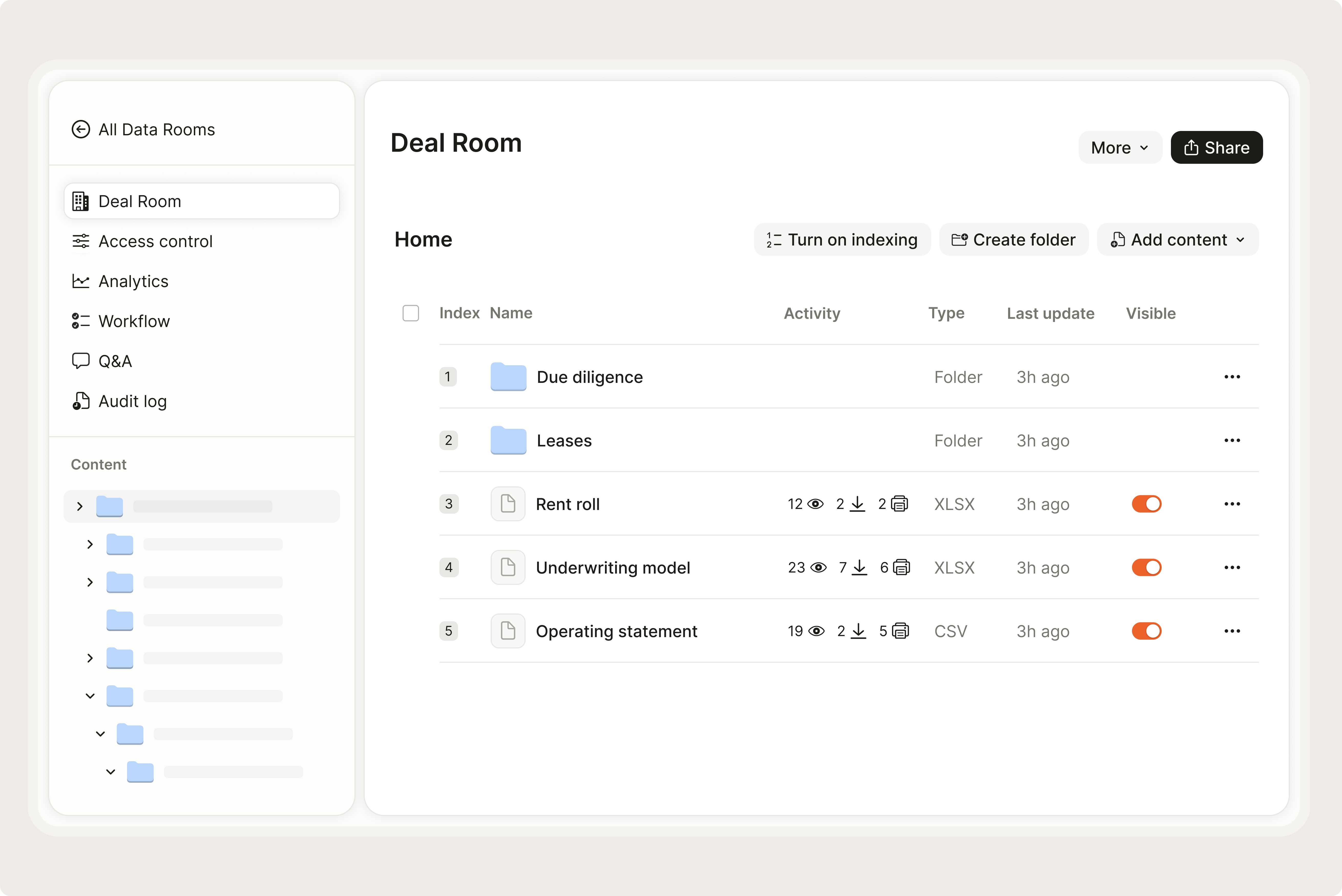
- 1.Upload Nebraska property files to a secure roomDrop ALTA title, NRD groundwater records, NDEE contaminated sites records, Phase I ESA, USDA FSA CRP records, NRCS WRE easements, FEMA FIRMs, 2019 flood records, drainage records, and lease pack into Ellty.
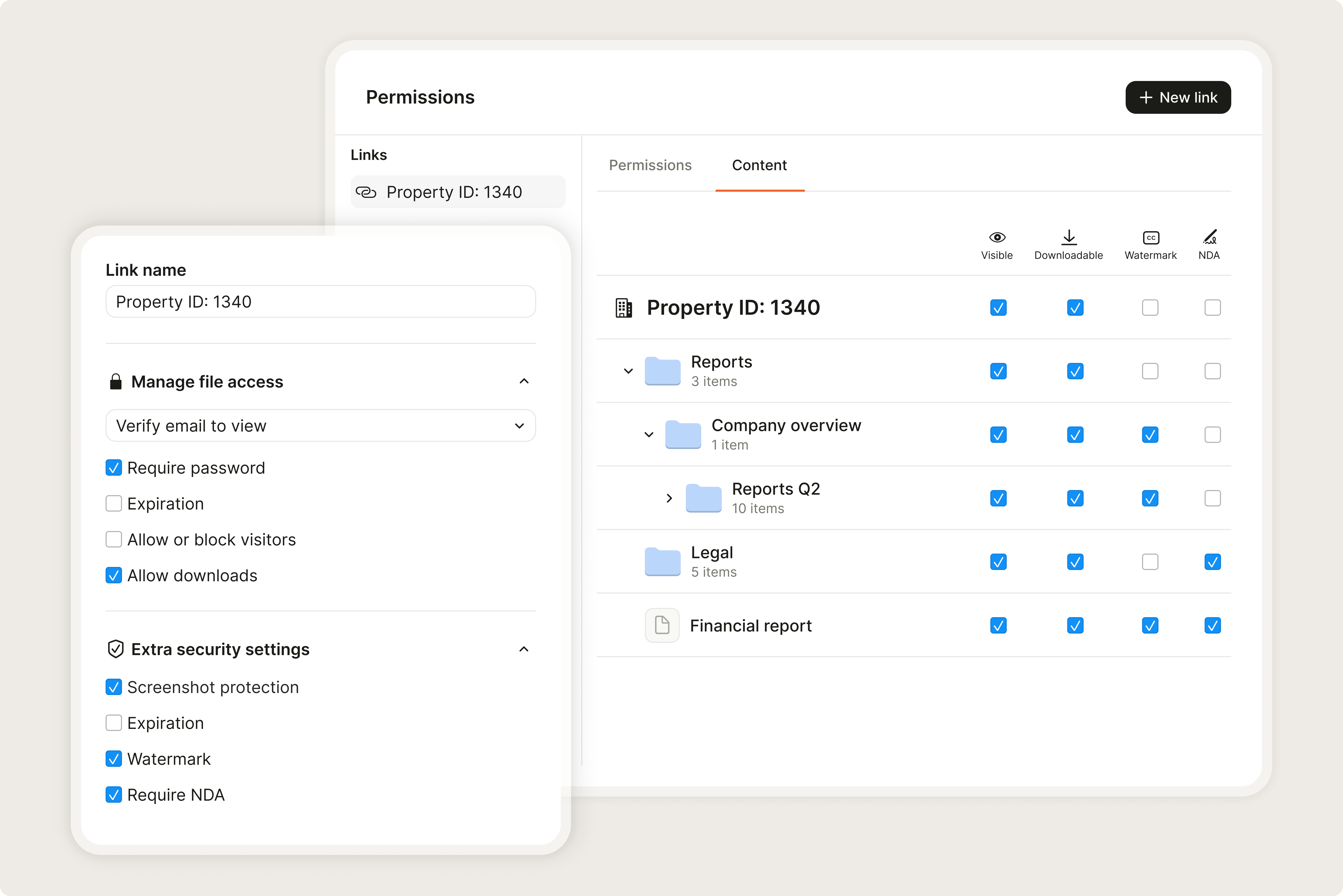
- 2.Give each advisor a scoped, tracked linkNE title attorney sees deed chain and drainage district records. NRD specialist sees groundwater permit and control area records. Environmental consultant sees NDEE records and Phase I/II. USDA specialist sees CRP and NRCS records. Lender sees NDEE VCP Certificate of Completion and valuation.
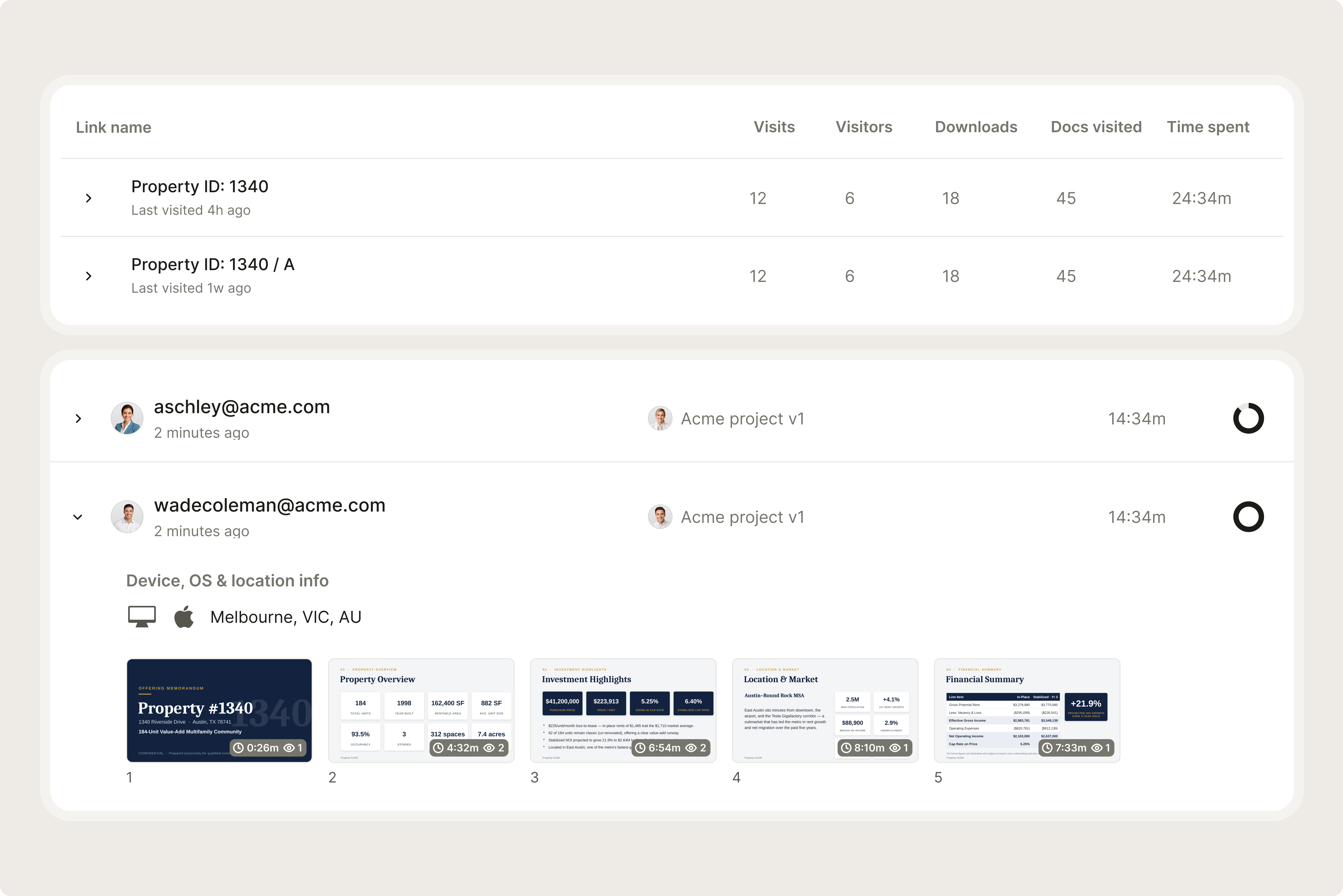
- 3.Monitor who reviews which documentsSee exactly which files each advisor opened and when. Catch NRD groundwater restrictions or CRP easement issues before they affect deal pricing or closing.
What makes Nebraska different
Nebraska's Natural Resources District (NRD) system is the most decentralized, basin-specific groundwater governance system in the US - and most out-of-state commercial buyers have never encountered it. NRDs are political subdivisions of the state established by NE law, each covering a river basin or aquifer area, each with elected boards of directors, and each with independent authority to set groundwater rules within their boundaries. The same commercial use (say, a food processing plant withdrawing 500 acre-feet per year from a well) might be completely unrestricted in one NRD, subject to a registration and annual reporting requirement in a second, and flatly prohibited under a moratorium in a third. The Integrated Management Act of 2004 added a further layer: in basins declared over-appropriated by the Nebraska Department of Natural Resources, surface water appropriators and groundwater users must share in meeting any shortfall, which can trigger new groundwater restrictions at any time. There is no single Nebraska groundwater permit database; each NRD maintains its own records. Contact the applicable NRD (and confirm which NRD covers the parcel - some commercial properties near basin boundaries are in one NRD for surface water and another for groundwater) before spending any diligence dollars on a groundwater-dependent NE commercial use.
The March 2019 Nebraska floods were the most costly natural disaster in state history, exceeding $1.4 billion in damage. The event was driven by a combination that is increasingly common in the Great Plains: a bomb cyclone producing rapid pressure drops, rapid snowmelt from a record winter snowpack, frozen ground preventing infiltration, and saturated rivers already near capacity. The Missouri River reached the highest levels on record at some gauges. Offutt AFB, one of the most strategically important USAF bases in the country, was flooded for months. Unlike a standard river flood that affects a predictable floodplain, the 2019 event also flooded areas outside mapped FEMA SFHAs because of the combination of ice jam backwater, overtopping of levees, and surface water accumulation on frozen ground. Post-2019 FEMA FIRM revisions expanded the SFHAs in some eastern NE counties, but commercial lenders have moved beyond FEMA FIRM reliance for any eastern NE river-adjacent commercial - they now commonly require post-2019 flood exposure analysis and elevation certificates as standard.
USDA conservation easements are a blind spot for standard ALTA title practice in Nebraska. CRP contracts are not typically recorded in the county register of deeds; they are administered by the county FSA office. A Wetland Reserve Easement may be recorded, or it may be carried only in NRCS county records. A buyer who commissions ALTA title, gets a clean commitment, and proceeds to closing without checking with the county FSA and NRCS offices can discover after closing that a significant portion of the commercial parcel is under a permanent WRE easement or a 15-year CRP contract that prohibits the intended commercial use. This is not hypothetical: Nebraska's agricultural legacy means a substantial share of its peri-urban commercial development pipeline consists of former farmland, a significant fraction of which has been enrolled in USDA programs. The county FSA office check takes one phone call and costs nothing. Do it before bidding.
Nebraska's Natural Resources Districts (NRDs) are established under the Natural Resources Districts Act (NE Rev. Stat. §2-3201 et seq.) and have authority to adopt rules and regulations governing groundwater quantity and quality management within their boundaries. Pursuant to the Integrated Management of Water Act (NE Rev. Stat. §46-715 et seq.), when a river basin is declared fully appropriated or over-appropriated by the Nebraska Department of Natural Resources, NRDs and the Department must develop an Integrated Management Plan specifying how surface water and groundwater users will share in meeting the over-appropriation. NRDs may impose groundwater control areas (§46-656.24 et seq.), require metering and reporting of groundwater withdrawals, restrict new well permits, or require users to hold groundwater offsets. The applicable NRD office is the authoritative source for the current groundwater management status and rules for any commercial property in Nebraska.
Timeline and cost in Nebraska
Weeks 1-2 cover kickoff: ALTA title commitment order, applicable NRD groundwater control area status check (phone call or written inquiry to NRD office), USDA FSA county office CRP check, NRCS county WRE and CREP records, NDEE contaminated sites database search, NDEE UST database search, FEMA FIRM (post-2019 update confirmation), Phase I ESA commission (NDEE-familiar consultant), zoning confirmation, drainage district membership, and lease abstraction initiation. Legal fees in this phase: USD 3,000-12,000.
Load all files into Ellty before advisors engage. Standard NE commercial: 30-60 days. NDEE VCP brownfield: 12-24 months for Certificate of Completion.
Weeks 2-4 cover deep review: ALTA title examination completion, Phase I ESA delivery (NDEE contaminated sites, NDEE UST, RCRA, Superfund), NRD written groundwater status confirmation, USDA FSA CRP contract details (if any), NRCS WRE/CREP easement records, drainage district assessment confirmation, post-2019 flood exposure review (eastern NE commercial), lease abstraction and estoppel review, zoning compliance, and insurance quotes. Costs in this phase: USD 5,000-20,000.
Weeks 4-8 handle resolution: Phase II ESA (if triggered), NDEE VCP enrollment (brownfield), NRD groundwater use permit (if needed for new use), CRP/WRE negotiation (if applicable), title exception clearance, documentary stamp tax calculation confirmation, and closing preparation.
NE total buyer acquisition costs for commercial: documentary stamp tax (up to 0.30% of purchase price, paid by grantor) + ALTA title insurance + legal/advisory + environmental (Phase I/II). Transfer-related closing cost from the buyer perspective is primarily ALTA title insurance premium; the documentary stamp tax is typically a grantor (seller) expense.
Running a Nebraska property deal from one room
Hold ALTA title, NRD records, NDEE VCP docs, USDA conservation easements, and lease files in one tracked Ellty data room.
Start free 14-day trialCommon questions about due diligence on Nebraska commercial property
- Standard Nebraska commercial deals take 30-60 days. NDEE Voluntary Cleanup Program (VCP) brownfield clearance: 12-24 months for Certificate of Completion. NRD groundwater use permit (if required for new commercial groundwater use): 3-12 months depending on NRD and use type. USDA CRP early termination process: confirm with FSA county office - typically requires 60-90 days notice and triggers repayment of past payments plus interest and penalty.
- Nebraska's 23 Natural Resources Districts (NRDs) are political subdivisions established by state law to manage groundwater and other natural resources within their river basin boundaries. NRDs have independent authority to set groundwater rules, including declaring control areas, imposing moratoriums on new wells, restricting pumping, and requiring offsets for new groundwater use. The 2004 Integrated Management Act (IMA) requires NRDs and the Nebraska DNR to jointly manage surface water and groundwater in over-appropriated basins. Commercial properties relying on groundwater must confirm NRD groundwater status before bidding - there is no single state database; each NRD maintains its own records.
- The Nebraska Documentary Stamp Tax (NE Rev. Stat. §76-901) is a state transfer tax at $2.25 per $1,000 of consideration (0.225%); counties may levy an additional $0.75 per $1,000 for a combined rate of up to $3.00 per $1,000 (0.30%). The tax is typically paid by the grantor (seller). It is paid at deed recording at the county register of deeds. Confirm the applicable county's rate before closing - not all Nebraska counties impose the maximum additional county levy.
- USDA Conservation Reserve Program (CRP) contracts are administered by the county Farm Service Agency (FSA) office, not recorded in the county register of deeds. A standard ALTA title search will not find CRP contracts. Wetland Reserve Easements (WRE) may be recorded or may be carried only in NRCS county records. A buyer who commissions ALTA title without separately checking with the county FSA and NRCS offices can discover after closing that enrolled farmland has a permanent WRE easement or 15-year CRP contract prohibiting the intended commercial use. Always check county FSA and NRCS offices for any peri-urban or former-agricultural NE commercial property.
- The March 2019 Nebraska floods caused over $1.4 billion in damage - the costliest natural disaster in state history. Driven by a bomb cyclone producing rapid snowmelt from a record winter snowpack onto frozen ground, the floods reached historic levels on the Missouri River and Platte River, flooding areas outside mapped FEMA flood zones including Offutt Air Force Base. FEMA declared major disaster DR-4420-NE and subsequently updated FIRMs in affected NE counties. Commercial lenders in eastern NE now commonly require post-2019 flood exposure analysis and elevation certificates for any Missouri River-adjacent or Platte River-adjacent commercial, beyond standard FEMA zone confirmation.
- NDEE's Voluntary Cleanup Program (VCP) is the primary brownfield liability protection mechanism for Nebraska commercial buyers. A buyer who completes cleanup to NDEE standards receives a Certificate of Completion providing regulatory closure. The Certificate is the standard NE brownfield lender clearance. NDEE's contaminated sites database and UST (underground storage tank) program database are publicly searchable. Omaha's South Omaha industrial corridor and Missouri River corridor have significant documented legacy contamination from meat-packing, railroad, and chemical operations requiring Phase II ESA before any lender will advance on former-industrial commercial.